News Archive (June 2023)
Wednesday 28th June
Is This A Rocky Harbour?
Leader, Report & Photos: Mel
Ible, Harbour Rocks, Brassington, Longcliffe, Aldwark
Winster top car park was the starting point for an 11 mile circular walk taking the hamlet of Ible reached by skirting the western edge of Bonsall Moor through a number of fields sporting many wildflowers. A leisurely coffee break was taken just below the disused Whitelow Mines. Leaving Ible the next part of the route included a steep but pleasant drop through woodland to reach the A5012 road, probably better known as the Via Gellia road. After crossing the road & a short climb through Orchid strewn fields, the track above Griffe Grange Valley was followed to reach New Harboro Farm for the climb to Harboro rocks for a photo opportunity and lunch at the trig point. Dropping down to and then crossing the high Peak Trail the walk continued through Brassington before the turn for the return journey through Longcliffe and the Hamlet of Aldwark. The Via Gellia road was re crossed just below Aldwark Grange followed by field paths to cross the moor like area south west of Winster. The walk was enhanced by the sight of many butterflies particularly the very active Gatekeeper. These butterflies were making good use of the many wildflower meadows present at this time of year mainly as a result of the “No Mow May” policies being followed by many farmers.

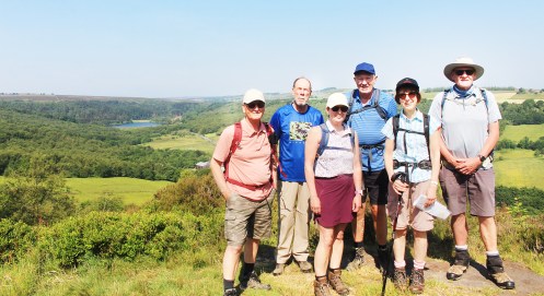
The group at Harboro Rocks
Saturday 24th June
White Hart Walk
Leader, Report & Photos: Mel
Calow, Westwood, Ringwood, Cuckoo Way, Staveley,, Pennine Trail (with short history of East Coast main Line connection).
Despite having to cancel the ‘bacon butties’ the Saturday group enjoyed a leisurely walk from the White Hart at Calow. An early part of the walk took the group through the now heavily leaved woods forming Westwood down through to the Ringwood Lake currently hosting colourful and extensive Lilly patches over much of its surface. Following a short coffee stop at the Hub the walk continued along the canal to the Staveley Basin currently hosting the very busy canal festival. Lunch was taken alongside the trail leading to Arkwright before branching off near the remains of the old Adelphi Iron Works. Time was taken at this point to discuss the layout of the compact and complex junctions which allowed trains to transfer from the East Cost to the Midland main line. The group then returned to the White Hart where a couple of members took the opportunity to partake of a refreshing drink. Thanks are due to the White Hart for once again allowing Ramblers the use of the pub car park.

Meadow Cranesbill
Wednesday 21st June
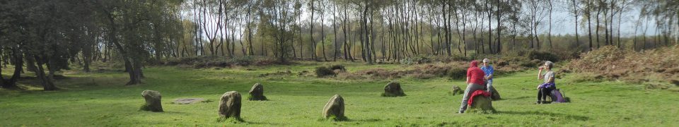
A Tomb With A View
Leader: Pauline & Clive Photos: Mel
Upper Moor Farm, Gotham, Minninglow, Royston Grange

At Minninglow – could not get them to dance around in costumes even if it was the summer solstice.
Saturday 17th June
Eyam Circular
Leader: Simon R Photos: Mel
Foolow, Grindlow, Great Hucklow, Abney Moor, Oaks Farm, Stoke Ford, Jubilee Plantation, Highcliffe.

Total ascent: 1500ft.
Wednesday 14th June
3 Trigs!
Leader & Report: Dermot Photos: Mel
18 walkers, including two visitors from Nottingham, one visitor from East Cheshire and two potential new members gathered on a beautiful bright warm summer’s morning, with a delightful cooling breeze in the main car park at Edale.
We left the car park at a brisk pace and made our way through the fields and lanes to Jacob’s Ladder and began our ascent. Unfortunately it was at this point our two potential new members dropped out due to exhaustion.

Kinder Low
After a short coffee stop at the top of Jacob’s Ladder we continued our ascent up to Kinder Low, our first trig point of the day. The view from the top over the Cheshire Plain was superb. From there we partially retraced our steps and made our way to Brown Knoll where we enjoyed our second photo shoot of the day before heading across the never ending stone block path to Rushup Edge where we enjoyed lunch.
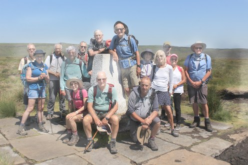
Brown Knoll
After lunch we enjoyed the company of many young students who were out doing their Duke of Edinburgh expeditions in search of their silver award. After a brief stop at the Lord’s Seat we were off up to visit our third and final trig point of the day, not to mention photo opportunity, Mam Tor, before commencing our descent back into Edale.

Mam Tor
Distance: 11.3 miles
Elevation: 2047 ft
Sunday 11th June
Walk around Chatsworth
(Rowsley Pasture, Calton Lees, Calton Pastures, Ballcross Farm, Edensor, Chatsworth House, Rabbit Warren, Hell Bank Plantation, Smeltingmill Brook, Rowsley Bar)
Leader, Report & photos: Mike
A group of 9 walkers including a visitor from Gedling Ramblers met in Rowsley. The group set off and went past the Peacock Hotel to follow the Derwent Valley Heritage Way along Rowsley Pastures to Calton Lees.. The weather was already warm and sunny at the start and the heat, as forecast, began to build for the duration of the walk. Regular stops were made during the walk to allow the group to take on fluids to mitigate the effects of dehydration .
The group continued up the bridleway to Calton Houses and onwards to reach the high point at Manners Wood and a well deserved coffee break. During this climb, the group was entertained by a Red Kite soaring close by. From the woods the group regained the footpath and proceeded along Calton Pastures to emerge on to the lane at Ballcross Farm. A 15 minute walk on this lane brought the group to the bridleway leading down to Edensor and the group walked along this track in to Edensor.
On entering this village, the group had a chance meeting with a couple who were unloading a vehicle. It was soon realised that this couple were in fact the Duke and Duchess of Devonshire. Extra brownie points for the leader!Leaving Edensor, the group entered the estate and headed to Chatsworth House for the lunch stop and made use of the toilet and refreshment facilities. From this busy location the group made steady progress uphill through the woods and tracks behind the house to reach the stone step stile and on to the track that leads through the Rabbit Warren. This was an exposed section and the full heat of the afternoon was now being felt by members of the group.
Welcome shade was provided as the group entered the woodland of Hell Bank Plantation. Following the footpath the group negotiated this woodland to emerge on to the closed road to Beeley. Walking down this lane, the group picked up the bridleway and made their way along this track to Fallinge Farm. A steep descent from here lead the group to the footbridge and waterfall at Smeltingmill Brook.
From here the group followed the path through Rowsley Wood and crossed Chesterfield Lane to then follow the footpath down to the A6 at Rowsley and back to the start. An enjoyable walk and good views throughout. Members of the group took the opportunity to visit the Grouse and Claret pub after to enjoy some cool drinks and reflect on the days exertions!

Distance: 12.6 miles
Elevation: 1550 ft
Saturday 10th June
Rivelin Circular
Leader: Isobel Photos: Mel
On a glorious summer morning a group of seven met at the Rails Road car park in the Rivelin Valley.
The route started by briefly following the south bank of the River Rivelin east and then turning uphill to cross the A57 and then climb steeply uphill through woodland, by Black Brook, to reach the top. The path along the edge continued through woodland and provided an impressive view of Rivelin Dams in the valley bottom. After crossing Redmires Road the way tracked into the site of Redmires Camp, originally a WW1 training camp for The Sheffield City Battalion, aka The Pals. It later became a prisoner of war camp and was also used as an auxiliary hospital to house smallpox patients. The bases of the Nissen huts are still visible amongst the brambles and ferns.
After a coffee stop the route followed the conduit to Redmires Reservoirs. It was lovely to see all three dams full of bright blue water now that the work on them is complete. Leaving the dams, we headed north across the moor towards the Rivelin Valley. Once back in the valley we turned east following the river, before crossing the A57 again and started the ascent up to Rod Side through fields. The path across the fields to Nethergate afforded views across the valley of the morning’s route. A short section of road walking was followed by the descent back to Rails through woods behind the former King Edward’s hospital.
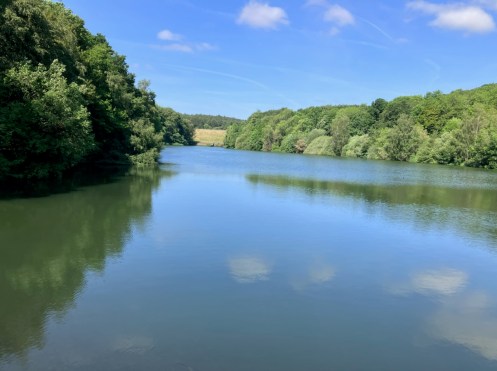
View point above Rivelin Mill Bridge looking towards Damflask which is just visible upper left
Distance walked: 10 miles.
Wednesday 7th June
Hean-Leah to Brackenthwaite
Leader: Liz Photos: Mel

Approaching the railway at Stretton
Monday 5th June
Barlborough circular
Leader & Report: Isobel
It was a lovely sunny evening for the first Monday evening walk of 2023 when a group of six walkers met on the village green in Barlborough. The planned walk was the Chaffinch Walk, one of a series of leafleted walks waymarked by Barlborough parish Council but unfortunately on the recce it became clear that this route is no longer suitable for taking a group on. Luckily the Fox and Magpie Walk, another leafleted walk, is still walkable and with a little modification it was extended to almost the advertised distance.
The route is mainly across fields and passes the remains of the drift mine The Fox and Magpie mine before going through High Wood and returns to Barlborough via the parkland near Barlborough Hall which is now a private school. It is thought the hall was designed by Smithson of Hardwick Hall and Woollaton Hall fame.
A further three evening walks are scheduled but if anyone would like to add a short evening walk (3-4 miles in their locality) it would be appreciated and could easily be added to the programme. The next available date is 31 st July. Contact Isobel McCormick to add walk.
Distance: 3.75 miles
Sunday 4th June
Chander Hill, Holymoorside
(Ashgate, Old Brampton, Linacre Reservoirs, Pratthall, Barlow, Rumbling Street, Bluster Castle and Frithhall)
Leader: Mike for Terry Photos & Report: Mike
A group of 11 walkers and a dog called Puzzle met at the lay by on Chander Hill. The group set off in the direction of Old Brampton. The weather was bright and sunny and it remained the same for the duration of the walk.
The group followed Westwick Lane before picking up the footpath through fields to emerge opposite the Church in Old Brampton. From here the group headed down the lane and took the footpath at Upper Ashgate Farm onwards to the bottom reservoir at Linacre Woods. Here the group took advantage of the toilets facilities at this location.
Taking the path at Kitchenflat Wood the group headed to Pratthall. Here the group had a coffee stop and admired the views over towards Wigley and Puddingpie Hill. Dropping down the hill the group followed the footpaths through Igmanthorpe and Jumble Hole to head towards Wilday Green and emerge via Crowhole Brook onto Bradley Lane. A short stretch of road walking brought the group to the footpath and subsequently they climbed slowly up to Rumbling Street on Far Lane.
At Wilday Green a further steady climb up to Grange Lane the group took the opportunity for a lunch break whilst taking in the views of Holmesfield and Owler Bar in the distance.
Suitably refreshed the group continued up to the highest point of the walk at Bluster Castle at 966ft. Descending through the collection of jumping fences in the fields below the group reached Birley Brook and headed towards the top reservoir at Linacre Woods.Skirting around this body of water the group picked up the footpaths to emerge at Hemming Green at Old Brampton. Continuing on the track and lane through The Birches and going past Frith Hall, the group climbed back onto Westwick Lane again and returned to the start point

Distance: 10.7 miles
Elevation: 1700 ft
…. previously on
chesterfieldramblers
![]()