Walks Database
![]()
Below we have compiled a list of example walks in the hope they may serve as inspiration for future walks by walk leaders new & old. All routes are circular.
You are welcome to download the .gpx files and use them directly on your navigation device / os maps, or use the pdf to plot the route directly onto a paper map.
We would strongly suggest you recce any route yourself and make changes where you see fit.
Walks are sorted by distance – for longer walks please scroll to the bottom of the page.
__________
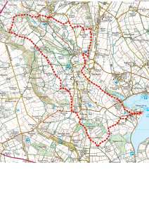
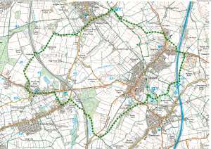
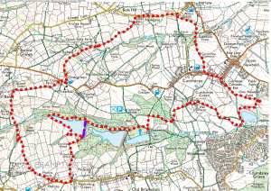
Get the Lead out
AREA: Castleton | DISTANCE: 7.5 miles | ASCENT: 1245ft
START POINT: POSTCODE: S33 6HF | GRID REF: SK1344,7367 | WHAT3WORDS: whisker.urgent.outlined
ADDITIONAL NOTES: Can be wet around Woodsets and alongside river Peakshole Water. 4 season walk but should be aware of some muddy sections. Parking is Road side near Odin Mine, old Mam Tor Road
DOWNLOAD GPX: Get the Lead Out GPX
DOWNLOAD PDF: Get the Lead Out PDF
OVERVIEW IMAGE (click to expand):

__________
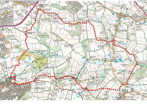
A loop around the Amber
AREA: Stretton | DISTANCE: 8 miles | ASCENT: 1000ft
START POINT: POSTCODE: DE55 6FN | GRID REF: SK3740,6047 | WHAT3WORDS: essays.passport.dice
ADDITIONAL NOTES: 3 season walk, can be wet along sections of field walking. Parking is at Ogston Reservoir West Car Park.
DOWNLOAD GPX: A Loop around the Amber GPX
DOWNLOAD PDF: A Loop around the Amber PDF
OVERVIEW IMAGE (click to expand):
__________
Barlow Millthorpe Circular
AREA: Dronfield | DISTANCE: 8 miles | ASCENT: 966ft
START POINT: POSTCODE: S18 3AX | GRID REF: SK3647,7957 | WHAT3WORDS: entire.shows.rapid
ADDITIONAL NOTES: Can be muddy in winter and spring through wooded sections. Parking is Rear of Coal Aston Village Hall
DOWNLOAD GPX: No Fuel on This One GPX
DOWNLOAD PDF: No Fuel on This One PDF
OVERVIEW IMAGE (click to expand):
__________
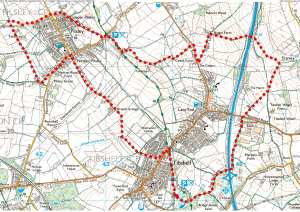
No fuel on this one
AREA: Barlow | DISTANCE: 8.1 miles | ASCENT: 1250ft
START POINT: POSTCODE: S18 7SE | GRID REF: SK3203,7508 | WHAT3WORDS: league.pythons.blaring
ADDITIONAL NOTES: Generally good for 3 seasons. Muddy sections, in winter and early spring. Short steep drop and climb – Grange Lumb. Parking is in Lay-by near Allen Wood Rumbling Street.
DOWNLOAD GPX: Barlow Millthorpe Circular GPX
DOWNLOAD PDF: Barlow Millthorpe Circular PDF
OVERVIEW IMAGE (click to expand):

__________
Where Oil Once Flowed
AREA: Tibshelf | DISTANCE: 8.4 miles | ASCENT: 720ft
START POINT: POSTCODE: DE55 5PG | GRID REF: SK3203,7508 | WHAT3WORDS: cans.contour.clinic
ADDITIONAL NOTES: Mostly good trails fields can be muddy in winter and spring. Car Park adjacent to fishing ponds – limited space
DOWNLOAD GPX: Where oil once flowed GPX
DOWNLOAD PDF: Where oil once flowed PDF
OVERVIEW IMAGE (click to expand):
__________
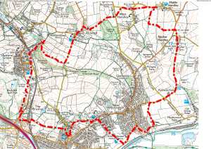
Wetlands and Airstrips
AREA: Dronfield | DISTANCE: 8.4 miles | ASCENT: 1070ft
START POINT: POSTCODE: S18 3AX | GRID REF: SK3646,7960 | WHAT3WORDS: begins.assure.gaps
ADDITIONAL NOTES: Generally good 4 seasons; muddy patches through woodlands. Car park to rear of Coal Aston Village Hall
DOWNLOAD GPX: Wetlands and Airstrips GPX
DOWNLOAD PDF: Wetlands and Airstips PDF
OVERVIEW IMAGE (click to expand):

__________
Peasants may Revolt
AREA: Whittington | DISTANCE: 8.4 miles | ASCENT: 1000ft
START POINT: POSTCODE: S41 9JZ | GRID REF: SK3840,7496 | WHAT3WORDS: limit.certified.posed
ADDITIONAL NOTES: Good for two seasons, wet muddy sections in Winter and early spring. Parking Side of road in front of museum.
DOWNLOAD GPX: Peasants May Revolt GPX
DOWNLOAD PDF: Peasants May Revolt PDF
OVERVIEW IMAGE (click to expand):
__________
From Pit to Pleasure Park
AREA: Pleasley | DISTANCE: 8.5 miles | ASCENT: 600ft
START POINT: POSTCODE: NG19 7PH | GRID REF: SK4997,6439 | WHAT3WORDS: blotches.amends.postcard
ADDITIONAL NOTES: Good, all seasons walk. Use section of route coloured magenta in inclement weather. Pleasley Country Park Car Park
DOWNLOAD GPX: From Pit to Pleasure Park GPX
DOWNLOAD PDF: From Pit to Pleasure Park PDF
OVERVIEW IMAGE (click to expand):

__________
A Geographical Centre
AREA: Tibshelf | DISTANCE: 8.5 miles | ASCENT: 600ft
START POINT: POSTCODE: DE55 5PG | GRID REF: SK4406,6007 | WHAT3WORDS: cans.contour.clinic
ADDITIONAL NOTES: Generally good, mostly trails and surfaced tracks, all seasons walk. Car Park adjacent to fishing ponds – limited space
DOWNLOAD GPX: A Geographical Centre GPX
DOWNLOAD PDF: A Geographical Centre PDF
OVERVIEW IMAGE (click to expand):
__________
Where Iron Once Brewed
AREA: Eckington | DISTANCE: 8.5 miles | ASCENT: 720ft
START POINT: POSTCODE: S21 3WF | GRID REF: SK441,7813 | WHAT3WORDS: respond.sheep.jeeps
ADDITIONAL NOTES: Generally Good some field and woodland walking, can be muddy, 3 seasons Walk. Countryside Services Car Park Renishaw, near Sitwell Arms
DOWNLOAD GPX: Where Iron Once Brewed GPX
DOWNLOAD PDF: Where Iron Once Brewed PDF
OVERVIEW IMAGE (click to expand):

__________
From Pond to Park
AREA: Tibshelf | DISTANCE: 8.5 miles | ASCENT: 560ft
START POINT: POSTCODE: DE55 5PG | GRID REF: SK4406,6007 | WHAT3WORDS: cans.contour.clinic
ADDITIONAL NOTES: Good, mostly surfaced tracks and trails. All seasons walk. Car Park adjacent to fishing ponds – limited space
DOWNLOAD GPX: From Pond to Park GPX
DOWNLOAD PDF: From Pond to Park PDF
OVERVIEW IMAGE (click to expand):
__________
Thorns but not Prickly
AREA: Bolsover | DISTANCE: 8.6 miles | ASCENT: 420ft
START POINT: POSTCODE: NG20 9HS | GRID REF: SK5298,7084 | WHAT3WORDS: spit.snooty.minimums
ADDITIONAL NOTES: Mostly dry suitable for all seasons. Langwith Whaley Thorns Station Car Park
DOWNLOAD GPX: Thorns but not prickley GPX
DOWNLOAD PDF: Thorns but not prickley PDF
OVERVIEW IMAGE (click to expand):
__________
Doing the Junctions
AREA: Staveley | DISTANCE: 8.8 miles | ASCENT: 510ft
START POINT: POSTCODE: S43 3WL | GRID REF: SK4351,7367 | WHAT3WORDS: shadow.grew.manliness
ADDITIONAL NOTES: Good, surfaced tracks and trails; one short section field edge walking can be muddy in winter. 4 seasons walk. Poolsbrook Country Park Car Park
DOWNLOAD GPX: Doing the Junctions GPX
DOWNLOAD PDF: Doing the Junctions PDF
OVERVIEW IMAGE (click to expand):

__________
Keep the Castle in Sight
AREA: Bolsover | DISTANCE: 8.8 miles | ASCENT: 800ft
START POINT: POSTCODE: S44 6HF | GRID REF: SK4733,7039 | WHAT3WORDS: filled.sleeping.mingles
ADDITIONAL NOTES: Generally good, all seasons walk. Can be a little sludgy between Woodside and Bolsover Woodhouse. Cotton Street Car Park
DOWNLOAD GPX: Keep the Castle in Sight GPX
DOWNLOAD PDF: Keep the Castle in Sight PDF
OVERVIEW IMAGE (click to expand):

__________
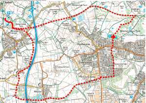
A view of the Western Side
AREA: Chesterfield | DISTANCE: 9 miles | ASCENT: 580ft
START POINT: POSTCODE: S40 1LP | GRID REF: SK3798,7118 | WHAT3WORDS: ruins.mount.never
ADDITIONAL NOTES: Good, mostly surfaced tracks and trails. Some field and woodland walking, sludgy in winter. 4 Seasons walk. Any convenient car park in Chesterfield, meeting In front of the Town Hall Rose Hill.
DOWNLOAD GPX: A View of the Western Side GPX
DOWNLOAD PDF: A View of the Western Side PDF
OVERVIEW IMAGE (click to expand):
__________
Gates Rakes and Reservoirs
AREA: Newbold | DISTANCE: 9.4 miles | ASCENT: 1100ft
START POINT: POSTCODE: S41 8XF | GRID REF: SK3554,7308 | WHAT3WORDS: given.plotting.drummers
ADDITIONAL NOTES: Generally good 4 seasons walk, may encounter muddy section – woods near Engine Hollow. Parking at Holmebrook Valley Visitors car park
DOWNLOAD GPX: Gates Rakes and Reservoirs GPX
DOWNLOAD PDF: Gates Rakes and Reservoirs PDF
OVERVIEW IMAGE (click to expand):
__________
End of list